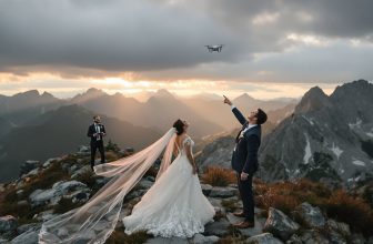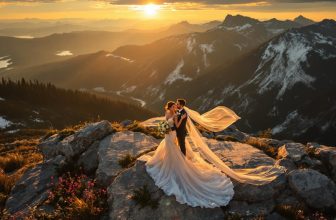
The Drone Restriction Map Wedding Couples Need (Major Metro Areas)
In major metro areas, a drone restriction map isn’t your magic key—it’s more of an airspace puzzle combined with maddening venue policies. With airports, controlled airspace, and local ordinances lurking, your wedding shoot could hit turbulence. But don’t fret—checking your venue’s coordinates and airspace classification should take just 10 minutes. Watch out too for those pesky stadium TFRs. Immerse yourself in these steps and discover exactly how to navigate your way to awe-inspiring shots.
Quick takeaway: the map you need is airspace + venue policy, not just a city label
When it comes to planning your dream wedding, you might think all you need is the perfect venue and a skilled photographer. But wait—have you considered the wedding drone restrictions by location? It’s not as simple as picking a city; you need a map that combines airspace details and venue drone airspace rules. Here’s what to do:
- Check Airspace: Verify whether you’re in Class G, B, or C airspace. This determines the level of FAA involvement.
- Venue Policies: Some venues outright ban drones or have strict timing rules. Know before you book. Venues typically require insurance from the drone show company, which adds another layer of complexity to your planning process.
- Permit Requirements: Depending on the city, you might need municipal permits for drone operations.
- Buffer Zones: Confirm you have at least 100 feet clearance from guests and structures.
Trust me, ignoring these could crash your wedding plans.
Why metros are tricky (airports, controlled airspace, stadium TFRs, local ordinances)
Maneuvering drone restrictions in metropolitan areas isn’t exactly a walk in the park—in fact, it’s more like traversing a minefield of rules and regulations. Wedding drone restrictions by location can get downright complicated due to:
- Airport Proximity: With major airports like Phoenix Sky Harbor demanding LAANC approval for nearby flights, it’s essential to avoid costly FAA fines.
- Controlled Airspace: Steering through Class B or C airspace means you’ll need ATC authorization, often requiring a Remote Pilot Certificate.
- Stadium TFRs: Planning around temporary flight restrictions near stadiums or events is non-negotiable.
- Local Ordinances & Municipal Restrictions: California cities have their own quirks, from Hermosa Beach’s permits to Napa’s park bans—each requiring careful attention. Notably, the FAA mandates reporting of incidents or near-misses within 10 days, underscoring the importance of adherence to safety protocols.
How to check your venue in 10 minutes (exact steps)
Checking your wedding venue for drone restrictions doesn’t have to be a headache—do it in 10 minutes flat. First, grab the venue’s coordinates and check for any nearby airports. Then, see if you’re in controlled airspace or if you need LAANC approval. Remember, flying over people is prohibited unless they are direct participants in the operation, so plan your flight path accordingly. Finally, verify any venue-specific policies and safety perimeter requirements—because nothing says romance like a drone crash, right?
- Find Venue Coordinates + Nearest Airports: Use GPS to pinpoint your venue and identify local airport proximity.
- Check Controlled/Restricted Airspace: Utilize LAANC or DroneZone to determine if you need authorization for your flight.
- Check Temporary Flight Restrictions: Look for any event-based restrictions that might spoil your day.
- Confirm Venue Policy + Safety Perimeter Requirements: Contact the venue to understand their specific drone rules and guarantee compliance.
Step 1: find venue coordinates + nearest airports
So, how do you guarantee your dream wedding venue isn’t a drone no-fly disaster? Start by pinpointing the venue’s GPS coordinates for an accurate airspace classification—because trust me, guessing won’t cut it. Next, immerse yourself in wedding drone restrictions by location. You’ll need the full street address to check FAA systems. Then, tackle the airport proximity assessment methods: measure how far the venue is from the nearest airports. A 5-10 mile radius from major airports often signals strict Class B or C airspace. Washington, DC is highly restricted airspace, so if your venue is nearby, you’ll need to plan strategically. Finally, don’t ignore restricted zone and no-fly zone identification. National parks and city centers are notorious for bans. Get cozy with FAA airspace tools or consult your venue coordinator for a quick reality check.
Step 2: check controlled/restricted airspace and authorization options (LAANC/approval)
While planning your dream wedding, the last thing you want is to have your drone grounded because you didn’t check the airspace restrictions. Imagine this: you’ve got the perfect shot in mind, but thanks to wedding drone restrictions by location, your drone is stuck on the ground. To avoid this fiasco, explore the aerial photography restrictions map. Check if your venue’s in controlled airspace. If it’s near one of those 600 airports with drone no-fly zones wedding nightmares, you’ll need LAANC approval for flights under 400 feet. LAANC provides access to controlled airspace through near real-time processing, making it easier for you to get the necessary authorizations quickly. Use FAA-approved apps like Aloft or DJI to submit requests. It’s quick if you follow the rules. A few clicks, and you’re cleared for takeoff. Don’t let bureaucracy ruin your day.
Step 3: check temporary flight restrictions (events, VIP movement, disasters)
If you think your wedding plans are all set, think again—temporary flight restrictions (TFRs) could throw a wrench in your aerial photography dreams. When it comes to wedding drone restrictions by location, you’ll want to be savvy about drone no-fly zones. Did you know events like marathons or presidential visits can generate temporary no-fly zones? Imagine your wedding day coinciding with a VIP movement—suddenly, your aerial photography location rules are in shambles. Disasters like wildfires can also lead to restricted airspace. To avoid surprises, check the FAA NOTAM database for real-time TFRs. Each venue has specific rules regarding drone flights, so ensuring compliance with both venue and FAA restrictions is critical. This extra step guarantees your dream venue isn’t unexpectedly off-limits, keeping your wedding day as magical as planned, without a drone dilemma.
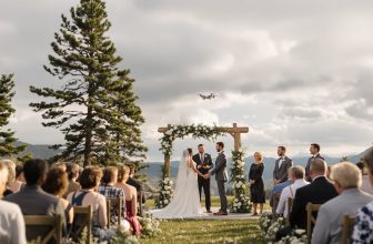
Step 4: confirm venue policy + safety perimeter requirements
Before you book that dreamy venue, let’s explore the less glamorous but essential world of drone regulations. You’ve got wedding drone restrictions by location to take into account. Start by asking the venue coordinator if they’ve got open space for drone launches or if they’ve hosted drone shows before. If they look puzzled, that’s a red flag—they might not know where drones are banned. Also, check if the venue falls within drone no-fly zones wedding planners dread, like near national parks or airports. Next, confirm the safety perimeter: FAA mandates 100+ feet from people and 50+ feet from buildings. Ensure guests are aware of drone safety guidelines and maintain a safe distance from drones in action. Oh, and don’t forget insurance. Verify the drone company adds your venue as “additional insured” just in case things go awry.
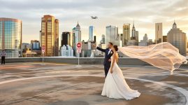
Major metro risk factors to watch (downtown cores, waterfronts, near stadiums)
Maneuvering drone restrictions in major metro areas isn’t exactly a walk in the park, especially when you’re eyeing those picturesque downtown cores, waterfronts, or bustling stadiums for your wedding shoot. You’re vying for those perfect aerial shots, but the sky isn’t always the limit. Here are some risk factors to keep in mind:
Navigating drone laws downtown is tricky; dream shots face airspace and event restrictions.
- Class B Airspace: Airports like Phoenix Sky Harbor blanket metros with restrictions needing LAANC approval. Miss a detail? Expect a denial.
- Temporary Flight Restrictions (TFRs): Big events equal big no-fly zones. Think Super Bowl, not drone bowl.
- Critical Infrastructure: Avoid flying near power plants or military bases—unless you fancy a hefty fine.
- Counter-UAS Systems: Your drone might be taken down by law enforcement. Yes, they can do that now. Non-compliance with these regulations can lead to fines reaching $27,500 and potentially void insurance coverage for unauthorized flights.
Table: what allowed can mean (allowed with authorization, allowed with limits, not allowed)
Maneuvering the tangled web of drone regulations in major metro areas might feel like you’re trying to score a touchdown in a minefield. Understanding what “allowed” means is essential. It’s not just black and white; there are shades of gray that can impact your wedding plans. Here’s a quick breakdown:
| Status | Meaning |
|---|---|
| Allowed with Authorization | You need permits or FAA Part 107 certification. |
| Allowed with Limits | Stick to 400 feet, daylight hours, and clear airspace. |
| Not Allowed | Forget drones near airports or national parks. |
You’ll need to check local rules, because municipalities love adding their own twists. Hermosa Beach, for instance, insists on permits and bans flights over schools. It’s crucial to familiarize with local regulations to avoid inadvertently violating drone laws. Always verify restrictions directly or risk a crash course in drone law.
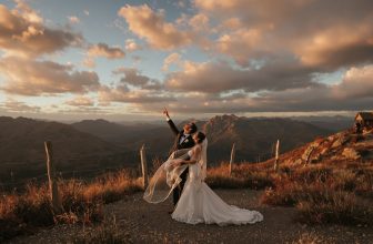
Backup plan: aerial-style shots without a drone (rooftop, balcony, gimbal, pole cam)
When your dream wedding venue says “no drones allowed,” don’t let it ground your vision for awe-inspiring aerial shots. Instead, consider these non-drone alternatives:
Don’t let “no drones” clip your wings; explore creative non-drone alternatives for stunning aerial shots.
- Rooftop or Balcony: Use these vantage points for remarkable panoramas. Just be sure to check safety protocols—no one wants a photographer taking an unexpected dive.
- Gimbal Stabilization: Capture smooth, cinematic shots while moving through the scene. It’s like having a drone in your hands without the flight risk.
- Pole Cam: Elevate your camera on a tall pole for striking angles. Think of it as a selfie-stick on steroids.
- Creative Angles: Use ladders or elevated platforms to mimic aerial perspectives. Sometimes, the best view is right above your head. Even though drones can elevate wedding shoots without significant financial investment, these creative alternatives ensure you don’t miss out on breathtaking shots.
For couples planning their wedding videography, it’s crucial to ask key questions to ensure quality and clarity in the services provided. Who needs drones when you’ve got creativity?
Educational only: confirm current rules and authorization for your exact date/time/location
Let’s face it, drone rules are a maze you’ll need to navigate if you’re planning to capture breathtaking aerial shots on your wedding day. It’s not as simple as launching your drone and snapping away. You’ve got homework to do.
- Check Federal Requirements: Keep your drone under 400 feet, maintain line-of-sight, and verify it’s registered. Commercial operators? Get that Remote Pilot Certificate—no shortcuts. Federal law mandates drone registration with the government, and it’s crucial to stay updated on any changes to these regulations.
- State-Level Hurdles: If you’re in one of the 25 states with surveillance prohibitions, know them. Seriously, ignorance isn’t bliss here.
- Metro Area Madness: Cities like NYC and San Francisco have their quirks. Permits, anyone?
- Local Ordinances: These can be a real buzzkill. Confirm specific city rules for takeoffs and landings.
Skipping this step? Not advised.